Local Natural Wonders - Day 60
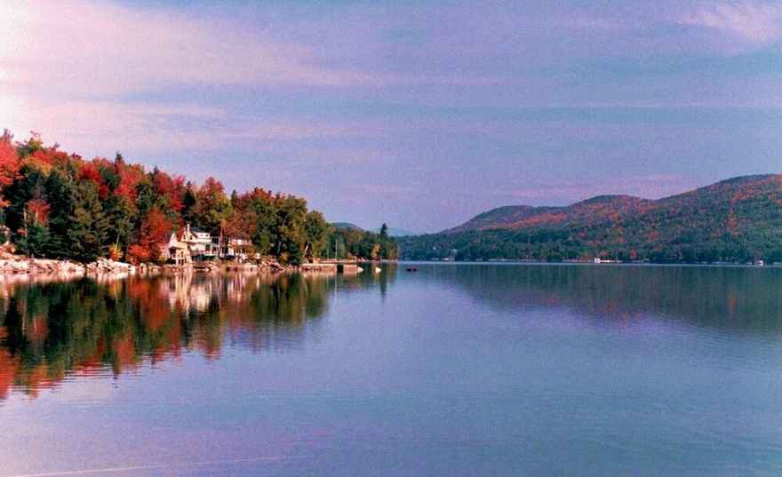
Local Natural Wonders Day 60 - Newfound Lake, Bristol, NH
Newfound Lake is known as one of the cleanest lakes in the world! It’s clear, pristine water is fed by eight springs. At 2.5 miles wide, seven miles long, and 168 feet and 183 feet deep at two different points, it is also one of the deepest lakes in New Hampshire. This lake has two lighthouses - Newfound Light House at Paradise Point Lodge on Route 3A in Bridgewater and Reed Lighthouse next to the Ledges on W. Shore Rd.
Natures preserves that include this lake are Newfound Audubon Center and Paradise Point Natural Area, both on N. Shore Rd in Hebron and Paradise Point Natural Area. Enjoy picnice areas, walking trails, a nature store, and canoe rentals at these locations.
There is plenty of hiking to do around Newfound Lake. The Lakes Region website lists these trails and mountains:
-
Mount Cardigan, Alexandria (3121’) – outstanding view of region. Cardigan Mountain Road out of Alexandria Center. Pond, picnic area, camping, AMC lodge, XC and backcountry skiing in winter. Part of 6000 acres of reserved land. Waterfalls on hike.
-
Big and Little Sugarloaf, Bristol (1361’) – Trailhead (Elwell Trail) just after entrance to Wellington State Park. Two peaks, one easy to moderate other more difficult. Nice view of lake from atop the Ledges cliffs. A trail splits off near trailhead to go to Goose Pond (easy hike).
-
Sculptured Rocks Natural Area, Groton – State Park and natural area. River formed gorge and waterfalls. Picnic area, swimming, hiking. Entrance to snowmobile corridor 11.
-
Round Top, Bristol – outdoor chapel on top – great views of Bristol. Very peaceful and serene. South 1/4 mi on 3A out of Bristol, Right on High St (after Federated Church). Follow straight until it turns to dirt at parking area.
-
Orange Rd, Groton – class VI seasonal road off of Sculptured Rocks Rd – Can follow to Mt. Cardigan (6 mi). Road follows river. Take some side trails and find a natural water slide and waterfalls.
-
Old Hill Village, Off Rt 3A, Hill – 10 miles of old roadways and trails on flood plain where Hill used to be along the Pemigewasset River. No wheeled vehicles allowed. Great place to bike, picnic and hike with pets and family. Shares parking area with Profile Falls.
-
Paradise Point Nature Center, North Shore Rd. Hebron – Nature preserve of Audubon Society. Lodge, hiking trails, canoe rentals, bird-watching on wooded shores on Newfound Lake.
-
Newfound Audubon Society, N. Shore Rd. Hebron – fields, picnicking, store, views of Hebron Marsh, bird-watching.
-
Wellington State Park, W. Shore Rd, Bristol – 1000 foot beach. Sheltered from weather by peninsula and two islands at its point, Cliff and Belle. Public boat launch and nature trails. 204 acres. Bathhouse, picnic tables, fishing and hiking.
-
Bridgewater Mountain , Bridgewater – Network of class IV seasonal dirt roads that go over mountain. Top of Poole Hill Rd and Bridgewater Mountain Rd is Sky Fields. Open field on mountain top with old estate. Great place to watch the weather move in. Take Dick Brown Pond rd off of 3A north in Bridgewater. Watch for signs to Poole Hill Rd.
-
Stinson Mountain, Rumney (2900’) Spectacular views of the Baker River Valley, and the Franconia and Sandwich Ranges. To reach Stinson, drive west from Plymouth on Route 25 to Rumney. Turn north and drive through the village to Stinson Lake. Bear right near the outlet of the lake and drive uphill. Take a sharp left-hand turn and you’re in the parking lot.
-
Rattlesnake, Rumney -Carr Mountain (1594’) Beginning on Bufallo Rd in Rumney this is a moderate trail that offers spectacular views of the Baker River Valley and its surrounding fields and mountains. To get to the trailhead take Route 25W from the Plymouth traffic circle. At blinking light, turn right into Rumney Village. In the village take first left onto Buffalo Rd. 2.5mi west of the village is a small parking area.
0 comments
Leave a comment
Please log in or register to post a comment